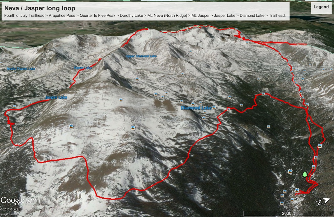
Fourth of July Trailhead > Arapahoe Pass > Quarter to Five Peak > Dorothy Lake > Mt. Neva (North Ridge) > Mt. Jasper > Jasper Lake > Diamond Lake > Trailhead
Google Earth route recreation below. I consider this rough, since I recreated the waypoints after the fact. But I took the time to follow trails and ridge lines I know I travelled, so it's not far off. One friend plugged in my data and Google Earth spit out 5,949 feet of gain, while mine got 5,455 ft. Not sure which one is closer to the truth. GPS also estimated 15.4 miles, but with all the route finding, I figure that's a bit conservative.

These are just for fun. What my iPhone split out comparing last week's Chicago Basin (San Juans) hikes and Torreys / Grays Peak climbs (14ers) vs. the distance and elevation gain on this IPW day. I don't completely trust the accelerometer in my iPhone, but it does give a good sense of relative effort on Sep 4th vs. two other hikes/climbs last week:

Early morning drive up past Nederland and Eldora to the Fourth of July trailhead. Only 2 hours of sleep after discovering late the night before that my AC unit has been leaking water in my basement for possibly 2 weeks or more. I digress...
6:13am - Trailhead
~6:40am - Reached the Fourth of July Mine relics
7:17am - Sunrise hit my back while on the Arapahoe Pass Trail.
7:23am - Reached Arapahoe Pass, turned right to scramble Quarter to Five Peak instead of left to Lake Dorothy and Mt. Neva's North Ridge.
8:15am - Climbed to the top of Quarter to Five Peak, exploring past the summit just a bit before turning around. ~12,300 ft.
8:40 - Back to the top of Arapahoe Pass junction and continued on to Lake Dorothy. Still haven't seen a soul, tuned my phone to Band of Horses since there was no one else's wilderness experience to ruin with my tunes. Feeling grateful for the solitude.
9am - Depart Lake Dorothy with iodine dissolving on my hydration bladder I topped off, even though it wasn't near empty. Started climbing up the Mt. Neva North Ridge, class 4, really fun stuff, and a short low class 5 wall with great exposure. That's when I started thinking about my solitude again. Tons of great features though, not a problem.
10am - emerged back on top of the Neva North Ridge line after prematurely dropping west to get around a deep notch just after the crux wall. By the time I felt committed to stay west I also realized I was probably off the best route, which must have gone around the notch to the east side of the ridge. Probably scarier exposure and loose rock on the west side at that point. If I fell on the west side of the ridge nobody will be down that steep ravine to the west, whereas traversing east of the ridge at least puts you in the view of anybody that may come up Arapahoe Pass and Lake Dorothy. Navigated it safely, but was glad to be back on the top of the ridge with it's beautiful view. Right when I got back to the spine of the ridge I saw I got there just in time to drop west again to a rough trail that I was clearly supposed to take. So I dropped west again, this time much easier, low class 3 stuff until quickly back up top within view of the real summit.
Listening to Covenhoven's very apropos lyrics from "Young at Heart" on my phone (my friend Joel Van Horne): "I've been abandoning safe bets for fleeting highs....lost is my own kind of found, and silence my favorite sound..."
10:15am - Neva Summit at 10:15. 12,821 feet. Later than I planned. Signed the summit register in a duct-tape wrapped mason jar. Started a clif bar. The sky is overcast now, but no gnarly looking systems on the horizon. Down the saddle quickly and on to Mt. Jasper.
11:26am - Mt. Jasper, summit. 12,923 feet (Google Earth GPS elevation profile I uploaded is approximate, so showing the wrong max elevation)
From there, I continued down from the summit along the south ridge, away from Mt. Neva. Reviewing Topo and Google earth images I saved on my phone. Snow levels and lake levels are a bit different. I opted for the longer route south to Diamond Lake vs. back to the Arapahoe Pass Trail.
1:13 pm - I used a weak cell signal to pull up Google maps and immediately realized I've been following the sounds of Jasper Creek, not the North Fork of Middle Boulder Creek, or one of the others in the canyons that split down from Mt. Jasper's snow melt. Because this canyon was off my topo maps I brought (and cell reception wasn't strong enough for a better live map from Google or another site), I was worried that it led somewhere that won't link up to Diamond Lake and ultimately the Fourth of July trailhead again, so I stay in one place and look up the USFS Boulder district ranger phone number I emailed Jaime with my itinerary for the day. Had a nice short chat in the phone confirming Jasper Creek and Jasper Lake below me do indeed link up to Diamond Lake and the Fourth of July trailhead. I figured, but it was reassuring to hear. It'll be a longer day now. How much longer I didn't ask. I committed to the longer loop, chalking it up to a more unique Neva/Jasper loop that I imagine far fewer people will be able to say they've done. I have iodine tablets for water and in a worst case scenario, I even have a puffy jacket compressed in my pack, first aid kit and my headlamp I started the day with, though I know it won't come even close to needing those. Ready for anything, but at least I now know for sure where I am and heading down to Jasper Lake instead of backtracking all the way back up Mt. Jasper summit to take a different way off the mountain.
In hindsight, I realize that I slightly misread the topo and satellite images I had stored on my phone when deciding where to drop down off Mt. Jasper. I chalked it up to the varying late season snow conditions and lake levels you can see from up there, always casting a sliver of doubt on what exactly you're looking at. That's an unacceptable excuse, and now I know better. Hindsight is 20/20. Next time I'm up there, I'll have irreplaceable benefit of personal experience to guide decision making. There are about three different ridge lines and therefor four canyons you can drop into. This time I erred one canyon too far south when I dropped down, since I wanted the longer loop to Diamond Lake. What I didn't realize until I was halfway down Jasper Creek was that I was signing up for an even longer loop than that.
Safe route finding along the north side of Jasper Creek proved annoying at times. Nothing even remotely resembling a trail, which can normally be fun, but large elevation drops meant I had to pick my lines carefully. Continued bushwhacking it and losing elevation over an hour toward Jasper Jake, which I can see below me in he distance. (Fun fact: Jasper Lake is also a reservoir, with water rights owned by Caribou Ranch, so water levels are syphoned off at strategic times of the year. At this time, it looked low with an uglier, muddy shoreline compared to the other natural little alpine lakes that dotted my day so far.)
1:23pm - Approaching Jasper Lake, I reach the first rough trail (looks more like a goat trail over trampled grass) I've seen since just before the Neva summit. Been navigating cross country for a while. I pass what looked liked a pretty well-used rebel fire pit at a backcountry campsite above the lake off the goat trail (I don't think fires are allowed up there).
On the east end of Jasper Lake I see the first people I've seen all day. They point me in the direction of the trail to Diamond Lake, where they just came from. They ask where I was coming from and seemed surprised at the answer.
Felt like a long hike/jog back to Diamond Lake, mostly because I knew my dog was waiting patiently for me at home and I was supposed to meet the HVAC technician at my house around 4pm. It's days like this when I wish I had a doggy door to the backyard. Feet started feeling the burn in my lightweight Scarpa Crux approach shoes, with which I'm otherwise happy. This is only the third time I've taking them out. Eventually I get to familiar Diamond Lake sometime after 3pm (I've been there 3-4 times before on short day hikes since moving to the Boulder area in 2007). Didn't check the time and plowed right by it, but snapped a picture.
It started raining good at 3:15pm. I recognized a dog that was approaching on the trail as "Dutch", my co-worker Grant's Dutch Shepard, on their way to Diamond Lake that afternoon. Chatted quickly with Grant and his friend on the trail, but had to keep moving.
3:49pm - Sipped the last drop of brown iodine-stained Lake Dorothy water from my hydration pack, but I've been on this trail many times and knew exactly how far away I was from my car. Reached my car (and Gatorade/water) at the Fourth of July trailhead at 3:55pm.
All in all, a great day, in part because it was a great learning and navigational experience and put a lot of varying alpine experience to use. Ironically, including the decision to not glissade down a particularly steep couloir on the other side of the ridge where I dropped down from Mt. Jasper. Although I feel good about that decision, that side of the ridge would have eventually led me back to Diamond Lake without the Jasper Lake detour (assuming I endured all the self-arresting that grade of snow would have required).
I'm glad I have this long loop under my belt, but next time, I'm looking forward to a simpler, faster Neva North Ridge climb, and a glissade down one of the Neva/Jasper saddle couloirs to an old airplane wreck, then quickly bushwhack back to the Arapahoe Pass Trail and back to Fourth of July. No getting sidetracked, just the quick highlights in what will then be much more familiar terrain.
Gotta love the IPW.
No comments:
Post a Comment